Salé, Morocco: Discover the Allure of the Atlantic's Gem
Salé, Morocco: Discover the Allure of the Atlantic's Gem
Can a place keep a medieval pulse while serving a modern metropolitan role across an estuary? This question frames an exploration of a coastal hub whose walls, gates, and riverfront tell layered stories.
Salé sits at 34.04528; -6.81778 on Morocco’s Atlantic coast, facing Rabat across the Bou Regreg. Established in the 11th century, it anchors a busy metropolitan area with more than one million residents in 2024.
The preserved medina reflects Marinid-era art and civic life. Visitors will note carved portals, madrasa courtyards, and a Great Mosque complex that reveal a maritime and scholarly past.
Practical access is simple: rail, Rabat-Salé tramway, and an airport that serves both cities. This guide will trace routes through gates, monuments, and riverside views to show how history and daily commute coexist.
Key Takeaways
- Salé blends a living Marinid medina with its role in a modern Rabat-Salé area.
- The Bou Regreg estuary shaped trade, defense, and religious life since the 11th century.
- More than one million residents make this a major metropolitan area in the country.
- Connectivity is strong: tram, rail, and a shared airport ease arrivals.
- The guide emphasizes architecture, riverside landscapes, and historical continuity.
Salé at a Glance: Atlantic setting, Bou Regreg riverfront, and a living medina opposite Rabat
Historic walls hug a compact old quarter while tram lines knit neighborhoods across water.
Where Salé sits
Salé sits on the right bank of the Bou Regreg, directly across river from the national capital. This proximity creates a steady flow between the two cities and a constant conversation at the waterfront.
Why visit now
The medina retains its Marinid perimeter and major gates such as Bab el‑Mrisa, offering a tangible sense of continuity. Lodging here gives quieter streets while museums and boulevards in Rabat remain minutes away.
- River frontage: quays and viewpoints reveal paired skylines and a compact urban fabric.
- Access: the Rabat‑Salé tramway (opened 2011, operated by Transdev with Alstom Citadis stock; two lines, 26.9 km and 43 stations as of 2022) eases cross‑estuary travel.
- Walkability: narrow lanes reward exploration of markets, mosques, and daily life.
"Start at the river to feel how trade, prayer, and movement shaped this side of the estuary."
From Sala Colonia to the Republic of Salé: a timeline of city, river, walls, and independence
A layered timeline shows how a small coastal settlement grew into a fortified maritime hub.
Ancient roots
Phoenician Sala and Roman sala colonia stood on the south side of the estuary. For many centuries this south-side site at Chellah linked Mediterranean trade and local markets.
Medieval foundations
In the 11th and 12th century Andalusi families formed the early urban core. They built first walls that framed civic life and ritual around the great mosque.

Almohad and Marinid phases
Yaqub al-Mansur ordered the great mosque in 1196 and is credited with a first bridge connecting shores. Later, Marinid patrons rebuilt fortifications and added water gates, including Bab el‑Mrisa in the 1270s.
Corsairs and modern politics
By the 17th century the port became a corsair base. The republic salé era saw Barbary pirates and the famed salé rovers, plus Spanish and French bombardments in 1628–1629. In the 20th century local protests and the “Latif” prayer helped fuel momentum toward independence.
| Period | Key change | Landmark |
|---|---|---|
| Ancient | Harbor settlement | Sala Colonia (south side) |
| Medieval | Urban walls | Early great mosque |
| Marinid | Fortifications | Bab el‑Mrisa |
| Early modern | Corsair republic | Republic Salé era |
Discover the city of Salé: the jewel of the Atlantic on the banks of the Bouregr
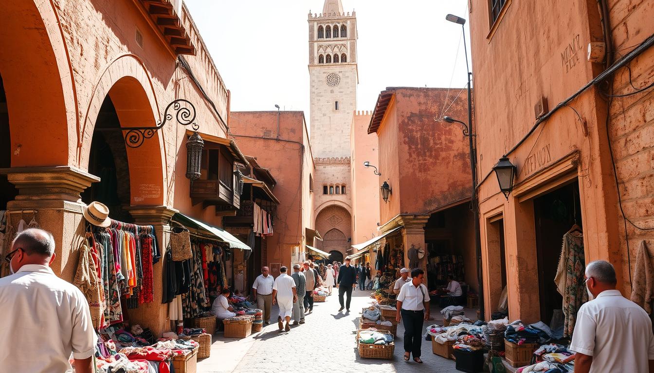
Approaching the old quarter, visitors meet a sequence of city walls, portals, and spiritual sites that mark centuries of civic planning. These elements form an ensemble where defense, worship, and daily life converge.
City walls and gates: Bab el-Mrisa monumental entrance to the old town
Bab el‑Mrisa (1270s) punctures the walls as a formal entrance. Its carved stone and heavy massing show early built Marinid techniques and an axial alignment that once controlled trade and movement.
Great Mosque and the heart of the medina
The great mosque, begun under Yaqub al‑Mansur in 1196 and later renovated, anchors ritual life. Beside it stands the madrasa abu al-hasan (1342), a compact school with timber ceilings, stucco, and zellij that embody a 14th century scholarly program.
Patron saints and mausoleums: Sidi Abdallah ibn Hassun and Ibn Ashir
The mausoleum of sidi abdallah ibn lies west of the mosque, while Ibn Ashir’s tomb marks the seaside cemetery. These patron saint shrines link devotion to shoreline protection and communal memory.
Funduq Askour maristan portal and Zawiya al‑Nussak outside the walls
The carved portal of Funduq Askour recalls a former maristan; its ornament preserves traces of medical charity. Nearby, Zawiya al‑Nussak (1356) offers a restored stone portal and austere lodgings for travelers and mendicants.
Marinid aqueduct and the shoreline facing the Atlantic Ocean
An aqueduct attributed to Abu al‑Hasan runs north of the medina. Its arcades once carried water to fountains and baths, linking hydraulic engineering with coastal life and the Atlantic frontage.

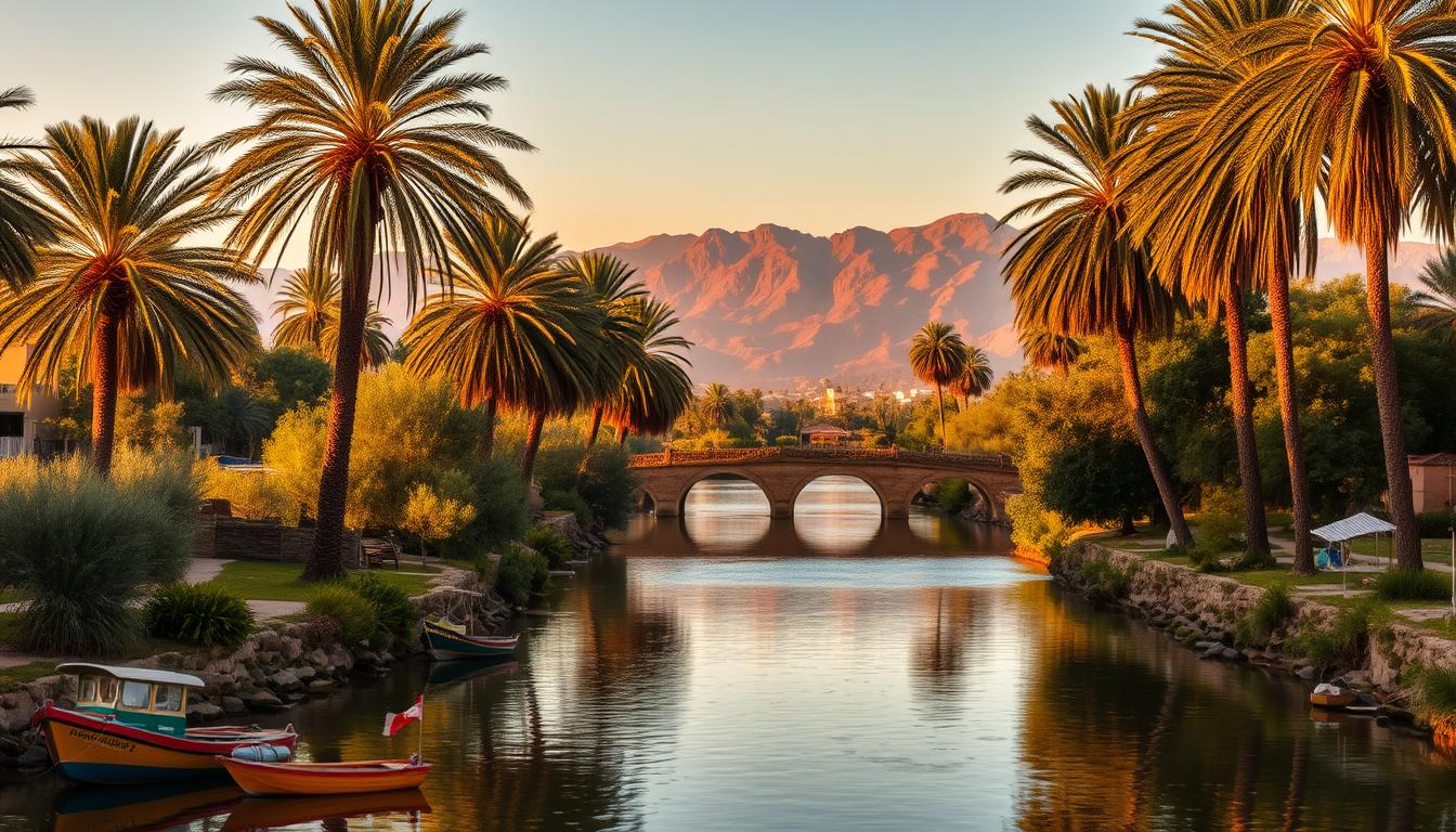
Bou Regreg experiences: rides across, river views, and exploring Rabat-Salé on both banks
A tram or a footstep across the water offers changing views of walls, minarets, and quays. This stretch frames everyday life and layered heritage along the bou regreg.
Ride across river: tramway crossings and bridges tying the cities together
The Rabat‑Salé tramway makes it easy to ride across river. Two lines cover 26.9 km and 43 stations, pairing quick transfers with panoramic bridge views.
Use a short ride across to move between quays and stations, or pause on a bridge to photograph gates and waterfront life.
Old town to old town: circuits between medinas and monuments
Plot an old town to old town itinerary: Salé’s medina to Rabat’s Kasbah of the Udayas and onward to Chellah. This route layers Roman remains and medieval walls in a compact walk.
Combine tram stops with brief walks across river rabat for museum visits and quiet café breaks that balance monuments with neighborhood rhythms.
Waterfront moments: sunset promenades and harbor traces near the south side
Stroll the regreg river promenades at dusk. Silhouettes of bastions and minarets catch late light while families and anglers gather on steps.
Read harbor traces on the south side: silted channels and water gates recall maritime work across a century. Small boats and ferries, when available, vary perspective and tempo.
- Tip: Pause on bridges to photograph converging axes.
- Note: Pair a river crossing with a riverside café for a fuller sense of the city.
Getting there and around today: Rabat-Salé Airport, ONCF trains, and tramway convenience
Travelers arriving by air or rail find a compact transport web that links waterfront sights with fast intercity options. Connections concentrate near the estuary, so moving between quays, museums, and medinas is straightforward.

Fly in: Rabat‑Salé Airport as the gateway
Rabat‑Salé Airport sits in Salé and serves the capital region, placing visitors minutes from central hotels and Rabat attractions. For short stays it is ideal and it supports regional hops across the country.
On rails and trams: Salé‑Ville, Salé‑Tabriquet, and the tram network
ONCF runs Salé‑Ville (main inter‑city) and Salé‑Tabriquet stations with regular services to Casablanca, Marrakech, Tangier, Fes, and other major cities. Salé‑Tabriquet offers easy local access east of the medina and links well to tram nodes.
- Tramway: two lines (26.9 km, 43 stations) cross the estuary; use the tramway rabat to reach museum districts and administrative quarters.
- Plan by time: peak hours favor trams for steady schedules; late nights may combine short taxi rides with tram segments.
- Scenic tip: include at least one ride across river—by tram or on foot—to reset orientation and enjoy skyline views near water.
When to go and what to pack: climate, seasons, and time by the water
Knowing when to visit helps balance comfort with meaningful time among walls, quays, and markets. Salé shows a Mediterranean-marine pattern: mild winters, warm summers, and steady breezes off the atlantic ocean.
Mediterranean-marine climate: Winter highs average about 17.2°C and summer highs near 25°C. Nights stay cool year-round. Annual rainfall sits around 522 mm and sunshine totals roughly 2,916 hours. Heat waves can push temperatures above 30°C.
Best time for medina and river walks
Spring and fall offer long sunshine hours and moderate warmth. These seasons suit detailed medina exploration and extended river promenades without heavy crowds.
Practical tips
- Pack layers: cool evenings call for a light jacket even after warm days.
- Carry water and rehydrate during market days and shoreline walks.
- Respect: modest dress and quiet behavior near mosques; some spaces are for worship only.
- Footwear: sturdy shoes handle cobbles, steps, and sandy patches along the waterfront.
- Photograph at golden hour: low sun highlights carved portals and textures.
"Shift touring to early morning or late afternoon when heat arrives, and use trams to shorten midday exposure."
Conclusion
In short, Salé's layered facades and quays condense centuries into short walks by water. From a gate-lined old town and city walls to views across river, the bou regreg frames movement and memory.
The great mosque and the madrasa abu al-hasan still shape daily life, while mausoleums for sidi abdallah ibn and coastal graves keep patron saint traditions visible. Earlier layers — from Sala Colonia to built marinid aqueducts and 14th century patronage — sit alongside a turbulent 17th century Republic Salé era of salé rovers and Barbary pirates.
Today, bridges, tramway rabat links and rabat-salé connections make river rabat crossings routine. Pause by the regreg river, read the gates and stones, and let this old town’s entrances and ports explain how a settlement holds its past while remaining a living city.
FAQ
Where is Salé located in relation to Rabat and the Bou Regreg?
Salé sits on the right bank of the Bou Regreg, directly across the river from Rabat. The two cities face one another along the estuary with bridges and tram links connecting their waterfronts.
What historic periods shaped Salé’s walls and monuments?
Salé’s fabric reflects many eras: Roman Sala Colonia roots, medieval Andalusi and Almohad developments, and substantial Marinid fortifications from the 13th–15th centuries. Later, 17th-century maritime history as the Republic of Salé influenced the town’s coastal identity.
How can visitors cross the Bou Regreg between the two cities?
Travelers may use road bridges and the Rabat-Salé tramway lines for quick crossings. Scenic boat rides and riverside promenades also provide views across the regreg river between the medinas.
What are Salé’s most important heritage sites to see?
Key sites include the Great Mosque and the medina heart, the Bab el-Mrisa gate, Marinid aqueduct remains, mausoleums for Sidi Abdallah ibn Hassun and Ibn Ashir, and the Funduq Askour maristan portal.
When is the best time to explore the medina and riverfront?
Spring and autumn offer the most comfortable conditions: moderate temperatures, pleasant daylight for walking, and cooling Atlantic breezes in the evenings. Layers are advisable for cooler nights.
How do travelers reach Salé by air and rail?
Rabat-Salé Airport serves as the nearest airport, with onward connections by taxi or tram. ONCF regional trains stop at Salé-Ville and Salé-Tabriquet, linking to Rabat and national rail routes.
What should visitors know about local customs and mosque etiquette?
Salé is a living medina with active religious sites. Dress modestly when visiting mosques, remove shoes where required, and ask permission before photographing people or shrines. Respectful behavior enhances the cultural experience.
Are there guided ways to learn about Salé’s maritime past, including the Salé Rovers?
Yes. Local guides, heritage tours, and museum resources explain Salé’s maritime history, from Barbary pirate activity and the Republic of Salé to its role in regional trade along the Atlantic and the estuary.
How walkable is the old town and what should visitors expect underfoot?
The medina features narrow lanes and historic surfaces: some cobbles and irregular paving. It is largely pedestrian, so comfortable shoes are recommended. Access for mobility needs can be limited in older quarters.
Can visitors combine a Salé visit with Rabat attractions?
Absolutely. Short crossings make it easy to pair Salé’s medina and riverfront with Rabat’s Chellah, the Kasbah of the Udayas, and other cultural sites. The combined itinerary showcases both banks of the estuary.


